Anti-surveillance architecture

2-0763561030Architecture seems increasing implicated in the generation of a ubiquitous surveillance society, not simply in the relatively longstanding modernist obsession with glass and visibility, but with security increasingly considered not as option but as infrastructure. It was nice to see at least some people concerned with creating anti-surveillance architectures. Two great examples are Deborah Natsios, and Eyal Weizman, and another I recently came across (via The Verge), is Asher J. Kohn, whose Shura City project, aims to create a living environment in an Islamic cultural context, that is protected from drone surveillance. As Kohn states:

“Shura City is constructed to be livable. It is built according to local logic, using local materials, and amenable to local needs. It is meantto be alien – but not hostile – from the outside while homey and familiar from the inside. It is meant to confuse the machines and their distant operators while creating a safe zone forpeople whose lives are being rended by war. Shura City is not about judgment on the survivors or destruction of their persecutors. Shura City is about using architecture to create a space for humanity in an increasingly inhuman sphere.”

Negotiating (In)visibilities

There’s an interesting new research network called ‘Negotiating (In)visibilies‘, one of those fascinating interdisciplinary collaborations (or collisions) that spans architcture, urban studies, cultural studies, arts and information (and probably). I’ve been asked to be an advisor and will also be giving one of the keynotes at what looks to be a really great opening confererence in Copenhagen, February 1-2 2012. Should be fun!

Helping robots find their way in the city

Many approaches to developing cities as automated environments, whether this be for robotics, for augmented reality or ubiquitous computing tend to take as their premise the addition of items, generally computing devices, to the environment. Thus, for example, RFID chips can be embedded in buildings and objects which could (and indeed in some cases, already do) communicate with each other and with mobile devices to form networks to enable all kinds of location-based services, mobile commerce and of course, surveillance.

But for robots in the city, such a complex network of communication is not strictly necessary. Cities already contain many relatively stable points by which such artificial entities can orient themselves, however not all of them are obvious. One recent Japanese paper, mentioned in Boing Boing, advocates the use of manhole covers, which tend to be static, metallic, quite distinctive and relatively long-lasting – all useful qualities in establishing location. The shape of manhole covers could be recorded and used as location-finding data with no need for embedded chips and the like.

It isn’t mentioned in the article, but I wonder whether such data could also be used for other inhabitants of the city with limited sensory capabilities: impaired humans? Could one equip people with devices that read the same data and use this to help sensorially-impaired people to navigate the city more effectively? On the less positive side, I also wonder whether such data would prove to be highly desirable information for use in urban warfare…

The City as Battlesuit

A really stimulating article by Matt Jones over at Future Metro, my new favourite site, which I have only just discovered thanks to David Barnard-Wills. This manages to combine several of my interests: urban futures, surveillance, security, ubicomp, SF and comics, into one tasty package – I’ll have to check out Matt’s own blog too.

Planning and protest in central Tokyo

Tokyo is a constantly changing stew of styles and forms, but don’t be fooled into thinking this is just ‘organic’ change. The capital of Japan is a playground for capital, local and global, and there isn’t much in the way of planning law or practice to stop the developers doing exactly what they want. It’s worth reading Andre Sorensen’s The Making of Urban Japan for a good account in English of why this is.

Inasmuch as the traditional morphology of machi (neighbourhoods) survive, it is largely due to either the unfashionable character of the area putting off developers, temporary lulls in the property market, or the sheer stubbornness of residents in refusing to being intimidated into selling land or putting up with the serial replication of blocks of manshon (typical 5+ storey apartment complexes). Strong property rights and small traditional plots do at least mean that it is more difficult to put together the land in what is called tochi kukaku seiri (land readjusment) to make really large developments which, as a result, tends to be restricted to whole sites that come on the market through things like the privatisation of Japan Railways (although some private developers like Mori Building Co. have managed private massive land readjustment projects like Roppongi Hills that I have researched on previous visits).

Of course the building regulations that do exist tend to favour development too, as they regard any old building as inherently unsafe (because of susceptibility to fire and earthquake) and it is thus very difficult, for example, to get traditional wooden houses repaired let alone new ones built. In addition, since the Edo period regulations have sought to open fire-breaks in the urban structure and increase the width of roads and alleyways – and again, the traditional and wonderfully characterful narrow roji (lanes) are very difficult to maintain as any new building has to be set back to newer road standards. This in turn tends to make the backstreets more accessible to faster-moving traffic and thus gradually dehuamanize and desocialize these places.

So communities have a lot to contend with and, despite the 196os environmental movements and machizukuri (community development) and the 1980s craze for ‘amenity’ (which included the promulgation of a ‘sunlight ordinance’ that was supposed to stop the construction of taller buildings that would block out the sun from neighbouring plots), the developers continue to try to squeeze in unwanted and inappropriately massive structures wherever they can.

We came across this small example of a local neighbourhood campaign to stop a new manshon being built at the edge of the historic (but much damaged) Yanaka district. It might not loo very exciting but you add these developments up all over the city and it goes a long way to explaining why Tokyo is gradually losing the remaining historic and social character that makes it a surprisingly human place to live, despite its size…

Death of the dojunkai apartments

As I mentioned the other day, after the Kanto daishinsai (Great Kanto Earthquake) of 1923, there were many changes to planning and architecture in Tokyo, in particular a series of experiments with introducing western-style elements into the city, including wider streets to accommodate trams (streetcars), and new concrete mass housing influenced by the modern movement.

Dojunkai, a special organisation under the Interior Ministry, was set to provide such things. Between 1924 and 1936, this agency built 16 apartment blocks out of ferroconcrete and wood in Tokyo and Yokohama. The best known were those in Daikanyama (near Shibuya) and on Omotesando Avenue in Aoyama. The latter were controversially demolished in 2003 by the Mori Building Company Ltd to make way for their soulless Omotesando Hills shopping complex.

Much less celebrated however, were the Dojunkai appartments in Nippori (not Minowa as most people seem to think) in Aarakawa-ku, just round the corner from where I am staying. They’ve been empty and crumbling for a while, but now the writing is very literally on the wall, saying that they will be demolished too. It’s a sad moment: another episode in the slow death of the utopian urban ideal of the Twentieth Century. It’s also a reflection of the very high land prices in Tokyo and relative lack of value in what is on the land at any time (see this article for a good summary of the difficulty of any architectural preservation in Tokyo).

Anyway, not only are they valuable historical buildings, they are also degenerating rather stylishly so, at the very least, I thought I should get in and take some pictures before it was too late. So I did – much to the surprise of a crew of local authority workers who were surveying the place as I came out. Here are some of the shots. I didn’t (yet) go into any of the indvidual apartments – all those I tried were locked and some chained too – though I might try to in the early morning this week before anyone is around.

Secure Cities

Following in the footsteps of leading urbanists like Mike Davis and Michael Sorkin, is a project led by Dr Jeremy Nemeth, an assistant professor at University of Colorado. which traces the degradation, securitization and privatization of what we used to optimistically refer to as ‘public space’. This project aims to map and quantify the space in three contemporary cities (New York, Los Angeles and San Fransisco) now restricted in the name of security. The website is online now, and their findings are summarized on the front page:

“Even before [the 9/11] terror attacks, owners and managers of high-profile public and private buildings had begun to militarize space by outfitting surrounding streets and sidewalks with rotating surveillance cameras, metal fences and concrete bollards. In emergency situations, such features may be reasonable impositions, but as threat levels fall these larger security zones fail to incorporate a diversity of uses and users.

Utilizing an innovative method developed by our interdisciplinary team, we find that over 17% of total space within our three study sites is closed entirely or severely limits public access. The ubiquity of these security zones encourages us to consider them a new land use type.”

(thanks to Dr Nemeth for the corrections to my original misattribution of his excellent project)

In Morro dos Prazeres: little ants changing the anthill?

One of our most interesting visits last week was to the favela of Morro dos Prazeres, north-west of Santa Teresa. Prazeres has one of the most astonishing views of Rio of any neighbourhood, with an almost 360 degree panorama of the city, it’s perspective to the south only interupted by the statue of Christ the Redeemer, which is hardly a bad view in itself! You might think that the last thing that favelados would care about was the view but they are well aware of the beauty of their location – the assumption that the poor an desperate would not care about such things is a rather patronising misconception. Elisa, the leader of the community association, at least, seems most proud of this asset and says that like many people she wouldn’t want to live anywhere else even if she won the lottery!

But Prazeres does have serious problems. For a start, it is a ‘hot’ favela, occupied by drug traffickers, who control ‘law and order’ in the place. There is therefore no ongoing police presence, although as with many such communities, the community association does have a relationship of sorts with local military police commanders through organised coffee mornings at which problems are discussed. Luckily, despite or because of the almost complete control of a particular gang which is well integrated into the community (i.e.: they are relatives of the more law-abiding members), there are not many problems with violence and the police, ‘thank God’ (says Elisa), have not raided the favela recently, as they have many others.

In fact, as we were visiting Prazeres, as the taxi driver rather anxiously pointed out as he dropped us a safe distance away, BOPE (military police special operations) were ‘invading’ two other favelas next to it, the very hot Morro de Correoa, and Sao Carlos. The operations left eight dead, and we think what we had assumed initially were fireworks was probably the sound of small arms fire in the Sao Carlos operation. However, when we asked a PM at a nearby police post whether Prazeres was safe to enter, he seemed rather blase and relaxed about the whole thing…

Elisa was another very impressive woman. In the absence of men – who, in the favelas are in many cases, either involved in the gangs, working outside, or unemployed and alcoholic – it seems that a whole generation of strong, courageous women has emerged to try to develop their communities from the bottom up. In the past they have benefited from various attempts by previous mayors to provide development for the favelas. Unlike some places, Prazeres does not have a school built during the regimes of populist left-wing Governor, Leonel Brizola (who seems to be fondly recalled in by almost all those we have talked to in the poorer communities). However there was a lot of intervention as part of the Favela Bairro (Favela Community) program of former Mayor, Cesar Maia, and it is this normalisation or the favelas through infrastructure, social and economic development, education, health and social services that Elisa said are the only long-term solution to the problems of Prazeres. The creche in particular is a source of continual delight to her, and her face lit up whenever it is mentioned.

With social development and education, Elisa argued, eventually the ‘cold’ and uncaring gangs will recruit fewer kids, and they will wither slowly away. Confrontation however, only strengthens them by driving more young people to support the ‘insider’ traffickers against the ‘outsider’ police. They must, she said, work like little ants, with lots of small efforts adding up together to long-term success… then perhaps the anthill of Prazeres will function as a normal community.

The beauty and cruelty of Rio de Janeiro

There is no reason why with the same infrastructural, social and economic support as anyone else in society would expect, that the favelas could not become truly beautiful without being cruel…

I am trying to think of something not too banal or cliched to say about Rio de Janeiro. It is rather difficult when I am sitting in my room in this artist’s house in Santa Teresa with its balcony overlooking the whole city centre and the bay and Niteroi on the other side, with bossa nova drifting up from the room below…

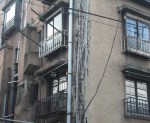
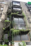
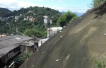
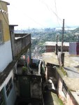
Being on a hill though, Santa Teresa is as good a place as any to try to get an initial feel for the geography of the place. Whatever you have read about Rio, however many pictures or films you have seen, it is still impossible not to feel utterly astonished, and in many ways delighted, by the place. Rio is unquestionably the most beautiful city I have ever been in. The shapes of the hills, the curves of the coast, the collision of architectures, the forest which comes right down into the city itself. Flying in, you could see its sprawl (this is a city of over 10 million people), but from the inside it is all small neighbourhoods, and more importantly all edges. One never seems to be entirely in one place in Rio, rather one constantly walks the boundary between city and forest, wealth and poverty, high rise and favela…

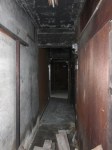
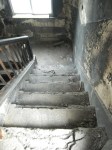
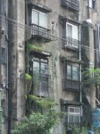
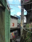
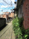
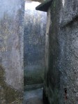
Because the poverty and the favelas are also inescapable. Unlike in San Paulo, where the favelas are located more on the periphery and can therefore be ignored by the rich, in Rio the rich and poor neighbourhoods are locked together like the fingers of clasped hands – but are they locked in mutual dependence or a death grip? The richer areas tend to run up the flattest land, whilst the favelas cling to the steeper slopes above and below. The disturbing thing for anyone who would try to form any swift opinion, is how beautiful the favelas are seen from my bird’s eye view. Rio’s beauty is matched by its cruelty, and even its cruelty is beautiful. The houses of the favelas follow the precarious topology of the hills, they pile onto each other, tiny alleys and stairs running in between. Self-constructed, they take the most natural forms that available resources allow, and in many ways are therefore the most human-looking places one can imagine. They most resemble the ancient towns of Greek islands or the Italian coasts, what Donald Ritchie called the ‘crammed mosaic’ of Tokyo neighbourhoods or Cornish fishing villages – the kinds of places that inspire deep feelings of the most intimate community.

But these are places of the most miserable poverty, crime and violence. From the bird’s eye view, you can’t smell the shit flowing in the streets, or see the tired, desperate faces of the inhabitants. It is because the architectural form, whilst it evolves from necessity, is not the cause of the socio-economic problems. Form does not, contrary to a still quite prevalent but regressive moral imagination, lead to a necessary moral or social outcome. The old rightist way of dealing with the ‘favela problem’, which was shared with leftist modernism, was the blank slate. Wipe out the favelas, put the people somewhere else, and everything will be okay. They were wrong. There is no reason why with the same infrastructural, social and economic support as anyone else in society would expect, that the favelas could not become truly beautiful without being cruel, why they could not come to be seen equally much as examples of the perfection of human settlement as Santorini or the old town of Lisbon, Mousehole or Mejiro…

The big question is how they get there. Rio’s multiple edges, its ubiquitous boundaries, are in many ways the most secure borders. The favelas are oppressed both by the most intimate micro-authoritarian internal control of the drug trafficking gangs, the uncaring external ‘prison-wardening’ and exploitation of the police and vigilante groups, and the utter fear and disgust of the richer classes who often see the favelados as nothing but criminals. I can’t suggest easy solutions to the fundamental problems, but part of what I am going to do over the next two weeks is to talk to a whole variety of people about the issues of surveillance and control and how some forms of surveillance should be broken or released and some should be made to work for people, not against them.

The downside of Brasilia

on foot, you are immediately confronted by the unpleasant reality of what is to the pedestrian effectively a huge expanse of carpark and highway separating the areas you might want to be. The functional split between the ‘zones’ only makes this worse.

Again, this is urbanism rather than surveillance, but here are some more musings and pictures on the urban form of Brasilia. Yesterday, I posted a lot of conventionally attractive shots of the buildings around the monumental axis of Brasilia. However, leaving aside the wider question of whether Brasilia outside of the planned centre functions as a city, there is a rather less beautiful side to the core.

This mainly has to do with the practical consequences of the philosophy behind the plan and particularly with functional separation and transport. As I noted when I first arrived, the city is dominated by roads. 5-lane highways run down either side of the monumental axis, and it is crossed by two major motorways in deep cuttings, with all the attendant slipways. These probably look very attractive as bold curving lines on a plan. They may even function if you are traveling by car (or bus). But on foot, you are immediately confronted by the unpleasant reality of what is to the pedestrian effectively a huge expanse of carpark and highway separating the areas you might want to be. The functional split between the ‘zones’ only makes this worse. Say you are in the hotel zone that I was staying in and you want to go out for a meal and a drink. Well, that’s 30-minutes walk to the nearest residential centre (where most of the evening options are located). Sure, you can take a taxi, but why should you have to? All the sports clubs are in separate ‘club zones’ even further away from either hotel, commercial or residential districts.

Now, okay, so the residential districts have most of their facilities (not including clubs) within walking distance – I said in my first impressions blog entry that I could actually imagine living here with a young family. And I still could. Natives of Brasilia are fanatical about the place. The residential districts work. You don’t really have to go anywhere near the soulless and secured shopping centres or take your chances running across massive motorways with uncaring drivers trying their best to ignore you. There is a simple metro system which runs between the districts and the centre (though it was largely closed for the building of new stations when I was there). You can walk around, between and under the blocks. They don’t appear to be totally obsessed with security in the manner of Sao Paulo or indeed most other large Brazilian cities. The blocks have concierges but not fences, walls and gates. Most of the windows do not even have bars.

But there is a reason and a price for this too. The residential zones are simply not socially mixed. Just about everyone who lives in the big blocks is a government or big corporate office employee. The ordinary workers and the poor live elsewhere entirely, in one of the satellite cities of Brasilia, and are bussed in and out via the busy central bus station every day. At the bus station, you find glimpses of the ‘ordinary Brazil’ – the cheap lanchonetes and pastelerias (in fact probably the best pasteleria I have found in Brazil so far)!, sidewalk vendors of DVDs and knock-off jewelry, the beggars, the hungry and the desperate. In many ways I felt more comfortable there than in the dry Le Corbusian dreamspaces of the government buildings.

Anyway, here’s some pictures of the ‘real Brasilia’ – or what it looks like if you stop focusing on the architecture and take a wider view!